
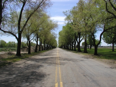
The allure of the open road. Something that almost all motorcyclists understand. The curiosity to see where that road goes, to see just how scenic the "scenic byway" on the map really is. The narrow, twisty road and its promise of fun. The road passing through the small town with the tiny grocery and deli, where they remember your name when you come back two years later. The road that goes up the mountain, where you can have your lunch and you can see a million miles in every direction.
Here are a few of my favorite local rides. It is by no means comprehansive, but I keep adding rides to it as I discover them.
Dear Visitor, please feel free to suggest additions to the ride descriptions; let me know about things I may have missed. Maybe I'll go take some more photos. Also feel free to suggest rides in the area that I can write up as I've written up the ones below. (I know I want to add a Mirror Lake ride.)
Local as in the Salt Lake/Utah Valley area. Or at least starting there. Many roads subject to closure in the Winter months, when no sane person would want to ride them, anyway. Call [801] 964-6000 if you are in the Salt Lake City area, or [800] 492-2400 elsewhere in Utah for a recorded message about road conditions. Or visit UDOT's Web Page, which is excellent. Since weather conditions are of such interest to motorcyclists, you may want to check conditions and the forecast at channel 4's weather page.
 |
|
 |
|
 |
|
 |
|
| |
|
Well, of interest to me, anyway.
I've never ridden the Trans-America Trail (TAT), Sam Correro's off-road, coast to coast, motorcycle adventure, but I want to, after having learned about it. The most compelling source of information, to me, was Mark Sampson's website and his descriptions and photographs of his journeys on the TAT.
My son, now 13, bugged me for a dirt bike for years, and I finally got him a KL250 almost a year ago. I taught him to ride, and of course rode the thing myself, but I didn't have a clue what a dirt bike was all about until I went tearing around the field behind our house... through the weeds, over the ditches, in and out of the stump holes, dodging the trees. What a complete kick in the pants!
But Andrew is now ready for something more fun and challenging than a closed circuit in a field, and we'll be traveling next spring and summer to my family's ranch in California, or a few places here in Utah that he can ride until he gets his license. But the ride I hope to take with him once he gets his license is part of the TAT.
I've shown Andrew bits and pieces of it, and I am sure he will be very enthusiastic about the prospect of a ride. I am now figuring out what bike to buy for this sort of ride, and think a KLR650 would be about right. It also would fit into the other uses I'd put it to.
Here's a link to the Trans-America Trail site:
Trans-America Trail
An aptitude test I took in high school told me that the ideal career for me would be that of a cartographer. I've always had a serious fascination with maps, so that might have been a good choice.
I have spent many hours exploring road maps, planning rides, dreaming of rides, finding things I need to go investigate. This is especially true when my motorcycle is out of commission, or when the weather is too rotten for long rides. There is something magical about sitting down with a nice road atlas on a stormy night, a cup of hot cocoa at your side, the wind rattling the windowpanes, as you picture yourself on your bike, turning those tiny lines of ink into memories.
And of course, take along a roadmap when you ride anywhere. Keep it in your jacket pocket when you ride to work, in case you and your friends want to ride somewhere interesting for lunch. Plus, being able to whip a map out of your pocket whenever anybody has a need for one will give you a great reputation as a die-hard motorcyclist, ready for anything, anytime.
I've found maps and atlases by Rand McNalley to the be best for my purposes, so I'm making a link available to their website. They also have some online features you may find useful. I like their Large Scale Road Atlas, because the larger the scale, the better to find and see the small roads. Plus my eyes are getting old along with the rest of me.
The Rand McNally Store features maps and navigational accessories for all your travel needs. Shop Now!